System and Method for Automated Subsurface Utility Infrastructure Mapping Using Pedestrian Smart Glasses Magnetometer Anomaly Detection with Computer Vision Surface Feature Correlation and Fleet-Aggregated Graph-Based Spatial Inference
Abstract
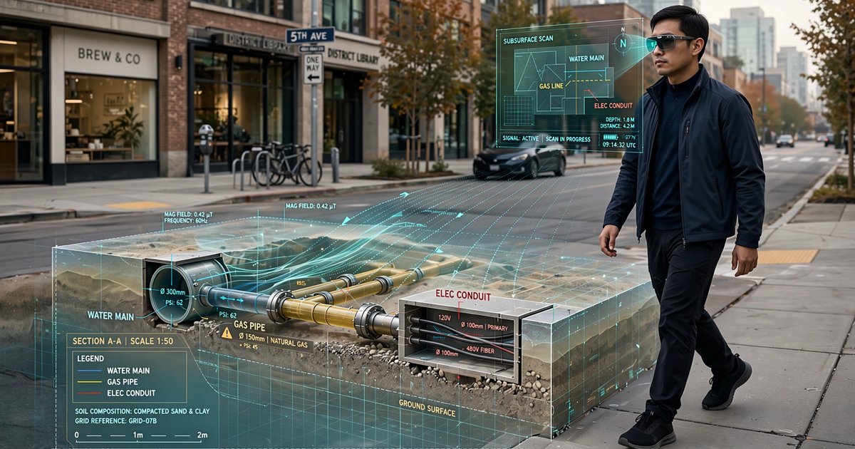
Disclosed is a system and method for continuously mapping subsurface utility infrastructure by fusing magnetometer anomaly signatures and computer vision surface feature detections from consumer smart glasses worn by ordinary pedestrians. Every buried ferrous utility (cast iron water mains, steel gas pipelines, ductile iron sewer lines, steel-armored electrical conduits) distorts the Earth's ambient magnetic field in a characteristic pattern that depends on the pipe's diameter, depth, material, and orientation. A three-axis magnetometer already present in consumer smart glasses (for compass and head-tracking functions) samples these distortions at 100 Hz as the wearer walks over or near buried infrastructure. Simultaneously, the glasses' forward-facing camera detects surface utility markers: manhole covers, valve box lids, utility paint markings, hydrants, and meter pits. An edge inference module (28,000 parameters, running on the glasses' existing application processor) extracts magnetic dipole anomaly candidates from the magnetometer stream, correlates them with visual surface feature detections and GPS position, and transmits a compact 96-byte observation packet per detected anomaly via the glasses' existing Bluetooth-to-phone cellular data link. A cloud-hosted graph neural network (520,000 parameters) aggregates observations from thousands of pedestrians traversing the same streets over days and weeks, resolving individual utility segments by clustering spatially-coherent magnetic anomaly signatures, fitting parametric buried dipole models to estimate pipe depth (0.3-3.0 m), diameter (50-900 mm), and material class, and connecting segments into a continuous network topology using the visually-detected surface access points as anchor nodes. The system produces Quality Level B subsurface utility maps (as defined by ASCE 38-22) from data collected passively during normal pedestrian activity, without ground-penetrating radar, vacuum excavation, or professional survey crews.
Field of the Invention
This invention relates to subsurface utility engineering and geospatial mapping, specifically to methods for detecting, locating, and classifying buried utility infrastructure using passive magnetic and visual sensing from wearable consumer electronics aggregated across a fleet of pedestrian users.
Background
The location of buried utility infrastructure in the United States is poorly documented, dangerously uncertain, and enormously consequential. The Common Ground Alliance (CGA) 2024 DIRT Report recorded 588,000 utility damage events in 2023, causing an estimated $30 billion in direct and indirect costs including service disruptions, emergency repairs, environmental remediation, and 67 fatalities. The root cause in most cases is the same: nobody knows exactly where the pipes and cables are.
The problem traces to how utilities were installed. Water, gas, sewer, electric, and telecommunications infrastructure was buried across decades by different utilities, contractors, and municipal departments, each maintaining separate and often paper-based records. The Federal Highway Administration estimates that 60% of existing utility records are inaccurate by more than two feet horizontally, and depth records are unreliable for 40% of installations. As-built drawings, when they exist at all, may reflect design intent rather than actual placement. Decades of road reconstruction, utility relocations, and abandoned-in-place infrastructure further degrade record accuracy.
Current subsurface utility mapping methods face fundamental tradeoffs between cost, coverage, and accuracy:
- One-Call / 811 locate services: The national 811 system dispatches locators who use electromagnetic pipe and cable locators (e.g., Radiodetection RD8200, Vivax-Metrotech vLoc3) to mark approximate utility positions before excavation. These locators require either a direct connection to the utility or an inductive clamp, work only on conductive utilities (not plastic pipes), and produce Quality Level B accuracy at best (±450 mm horizontal per ASCE 38-22). Locators are deployed reactively per excavation ticket, not for systematic mapping. A single locate visit costs $50-150 and covers only the excavation footprint.
- Ground-penetrating radar (GPR): GPR systems (e.g., GSSI UtilityScan, IDS GeoRadar Opera Duo) transmit electromagnetic pulses into the ground and record reflections from buried objects. GPR can detect both metallic and non-metallic utilities and can achieve Quality Level A accuracy (±15 mm) when combined with survey-grade GPS. However, GPR requires a trained operator pushing a cart or towing a trailer at walking speed, costing $2,000-5,000 per lane-mile. GPR performance degrades severely in clay soils (signal attenuation >30 dB/m at 400 MHz), saturated conditions, and areas with extensive rebar or aggregate backfill. Complete municipal GPR surveys are financially prohibitive: mapping a mid-size city's 3,000 lane-miles of streets would cost $6-15 million.
- Vacuum excavation (potholing): The gold standard for utility verification, vacuum excavation physically exposes the utility at specific points, achieving Quality Level A. Each pothole costs $500-2,000 and takes 2-4 hours. Potholing is a verification method, not a discovery method; you must already know approximately where to dig.
- LiDAR and surface survey: Mobile LiDAR (e.g., mounted on survey vehicles) can detect and geolocate surface utility features (manholes, valve boxes, hydrants, junction boxes) at high accuracy and speed. However, surface features do not reveal the subsurface geometry between them. A manhole indicates a sewer line passes through it, but the pipe's depth, alignment, material, and condition between manholes remain unknown.
- Magnetic surveys: Professional magnetometer surveys using cesium vapor magnetometers (Geometrics G-858, $30,000-50,000/unit, 0.01 nT sensitivity) or fluxgate arrays can detect ferrous utilities at depths up to 5 meters. These surveys are used in archaeological prospection, unexploded ordnance detection, and occasionally utility locating. The equipment cost, trained operator requirement, and per-survey deployment model limit their use to high-value sites. No system has been proposed that uses consumer-grade magnetometers at fleet scale to achieve comparable coverage.
Meanwhile, consumer smart glasses are approaching mass adoption. Meta Ray-Ban smart glasses shipped an estimated 7 million units by early 2026 with EssilorLuxottica targeting 20 million cumulative units by year-end. XREAL, Even Realities, and multiple Android XR partners are launching display-equipped smart glasses in 2026-2027. Every one of these devices contains a three-axis magnetometer (for compass heading and head-tracking), a three-axis accelerometer, a three-axis gyroscope, GPS or assisted positioning, and one or more cameras. The magnetometer in current-generation smart glasses (typically Bosch BMM150 or MEMSIC MMC5983MA) provides 0.3 μT resolution at 100 Hz sampling, roughly 30x coarser than a cesium vapor survey magnetometer but sufficient to detect the 1-50 μT anomalies produced by ferrous utilities at typical burial depths of 0.5-2.0 meters.
The critical insight this disclosure exploits: a single pedestrian's smart glasses magnetometer reading at one point is noisy and ambiguous. But thousands of pedestrians walking the same sidewalk over weeks generate a dense, multi-angle, multi-altitude (different wearers are different heights) sampling of the same magnetic field, with each traverse providing an independent realization of the anomaly pattern. Statistical aggregation across the fleet suppresses the noise floor by a factor of √N, where N is the number of independent traversals, pushing the effective detection threshold from ~5 μT (single pass) to ~0.15 μT (1,000 passes), approaching professional survey sensitivity. No prior art combines consumer-grade wearable magnetometers at fleet scale with computer vision surface feature anchoring and graph neural network spatial inference to produce systematic subsurface utility maps.
Detailed Description
1. Magnetic Anomaly Detection from Smart Glasses
A ferrous utility pipe buried at depth d below the surface and offset horizontally by distance x from the measurement point produces a magnetic field anomaly that can be modeled as a horizontal cylinder with permanent or induced magnetization. For a cast iron water main (150 mm diameter, 1.2 m depth, magnetic susceptibility χ ≈ 1.5 × 10⁻³ SI), the peak total field anomaly at the surface directly above the pipe is approximately 8-15 μT, well above the 0.3 μT noise floor of consumer MEMS magnetometers. The anomaly pattern has a characteristic bipolar shape in the component perpendicular to the pipe axis, with a peak-to-trough width that encodes the pipe depth. For a steel gas pipeline (100 mm diameter, 0.8 m depth), the anomaly is 3-8 μT. For a ductile iron sewer trunk (600 mm diameter, 2.5 m depth), the anomaly is 5-20 μT.
Non-ferrous utilities (PVC water mains, HDPE gas pipes, fiber optic conduit) do not produce magnetic anomalies and cannot be detected by this method. However, most non-ferrous utilities have metallic tracer wires installed alongside them (required by OSHA best practices and many state regulations), and these wires produce detectable anomalies at shallow depths. Additionally, non-ferrous pipes are often located between visible surface access points (cleanouts, valve boxes) that the camera subsystem can detect, enabling topological inference even without magnetic detection.
The primary challenge for pedestrian-worn magnetometers is interference. A smart glasses magnetometer at head height (~1.6 m for an average adult) is closer to vehicles, power lines, and structural steel than to buried utilities. The system addresses interference through three mechanisms: (a) motion-compensated filtering that removes the wearer's own head motion signature (calibrated during initial setup using a figure-eight calibration gesture), (b) temporal filtering that distinguishes static anomalies from buried infrastructure (which appear at the same GPS location on every traverse) from transient anomalies from passing vehicles (which appear randomly), and (c) spectral separation exploiting the fact that 50/60 Hz power line interference produces a characteristic narrowband signature that can be notch-filtered, while the DC magnetic anomaly from a buried ferrous pipe is broadband and position-dependent.
2. Computer Vision Surface Feature Detection
The forward-facing camera on the smart glasses continuously processes the visual field for utility-related surface features. A lightweight object detection model (MobileNetV3-Small backbone with SSD detection head, 2.5M parameters, running at 15 fps on the glasses' NPU) detects and classifies the following surface features:
- Manhole covers: Classified by utility type from embossed text and pattern recognition (SEWER, WATER, ELECTRIC, TELECOM, STORM DRAIN). Municipal-specific cover patterns are learned incrementally from fleet observations. Geometric features (round, rectangular, triangular) encode utility type per local convention.
- Valve box lids: Small rectangular or round surface-mounted boxes (typically 130 × 250 mm or 150 mm round) indicating buried water, gas, or sewer valves. Detected via shape and context (proximity to curb line, spacing patterns).
- Hydrants: Fire hydrants indicate the presence, approximate depth, and diameter of the water main they connect to. Hydrant type (dry barrel vs. wet barrel) and outlet configuration encode regional standards. Detected via shape, color (NFPA 291 color coding indicates flow capacity), and height profile.
- Utility paint markings: APWA Uniform Color Code markings (red = electric, yellow = gas, blue = water, green = sewer, orange = telecom, white = proposed excavation) detected via color segmentation with OCR for any directional text or depth callouts.
- Meter pits and pedestals: Gas meter risers, water meter pits, and electrical transformer pads indicate service lateral locations and directions.
- Pavement patches and utility cuts: Linear pavement patches crossing the roadway indicate past utility installation or repair. The patch geometry (width, orientation, endpoints) constrains the utility alignment and depth.
Each detected surface feature is geolocated using the glasses' GPS/GNSS receiver (2-5 m accuracy outdoors) refined by visual odometry from the IMU and camera (improving relative accuracy between features to ±0.3 m over 50-meter spans). Features are assigned a confidence score, and detections from multiple pedestrians viewing the same feature are merged using weighted averaging to improve geolocation accuracy to ±0.5 m absolute.
3. Edge Inference Module
An edge inference module running on the smart glasses' application processor (Qualcomm Snapdragon AR2 Gen 2 or equivalent, with dedicated NPU) performs three real-time tasks:
Task A: Magnetic anomaly candidate extraction. The module applies a sliding-window matched filter to the three-axis magnetometer stream (100 Hz, 300 samples/second total). The matched filter template is the theoretical anomaly profile of a horizontal ferrous cylinder at 1.0 m depth traversed perpendicularly, convolved with a Hanning window. When the matched filter output exceeds a SNR threshold of 3.0, the module records the peak amplitude, the anomaly width (measured as the distance between zero-crossings of the derivative), the angle of the anomaly principal axis relative to the walking direction, and the GPS position. The anomaly width directly encodes pipe depth via the geometric relationship: depth ≈ 0.56 × anomaly half-width for a buried horizontal cylinder. This relationship, derived from Blakely (1996, Potential Theory in Gravity and Magnetic Applications), holds to within ±15% for the depth range 0.3-3.0 m and typical pipe diameters.
Task B: Surface feature detection. The MobileNetV3 object detector processes camera frames at 15 fps and outputs bounding boxes with class labels and confidence scores for utility surface features. Features with confidence above 0.7 are recorded with their GPS position, class, and a 64-byte perceptual hash of the detection crop for deduplication across multiple sightings by the same or different wearers.
Task C: Anomaly-feature correlation. When a magnetic anomaly candidate occurs within 10 meters of a detected surface feature, the module records the spatial relationship (distance, bearing, anomaly axis angle relative to the feature) as a correlation event. These correlations are the highest-value observations in the system, because a magnetic anomaly near a labeled manhole cover or valve box confirms the anomaly's utility association and provides a ground-truth anchor for the magnetic signature of that utility type in the local geological context.
The module transmits a 96-byte observation packet per detected anomaly or surface feature: latitude (4 bytes), longitude (4 bytes), altitude (2 bytes), timestamp (4 bytes), observation type flag (1 byte: magnetic anomaly, surface feature, or correlation event), magnetic anomaly amplitude (2 bytes, 0.01 μT resolution), anomaly width (2 bytes, 0.01 m resolution), anomaly axis angle (2 bytes), surface feature class (1 byte), surface feature confidence (1 byte), wearer height estimate (1 byte, from initial calibration, affecting magnetometer-to-ground distance), walking speed (2 bytes), heading (2 bytes), and a 68-byte payload for the perceptual hash, extended metadata, and checksum. Packets are transmitted via Bluetooth LE to the paired smartphone, which batches and uploads them via cellular data. Daily data volume per active wearer: approximately 50-200 KB (500-2,000 observations during typical urban walking).
4. Fleet-Aggregated Graph Neural Network Inference
The cloud-hosted inference engine processes the aggregated observations from all participating smart glasses wearers to construct and continuously refine a subsurface utility map. The pipeline operates in four stages:
Stage 1: Spatial clustering. Magnetic anomaly observations are clustered using HDBSCAN (minimum cluster size 5, minimum samples 3) in 3D space (latitude, longitude, anomaly axis angle). Each cluster represents a candidate utility segment. Surface feature observations are similarly clustered with a tighter spatial threshold (2 m) to merge multiple sightings of the same manhole or valve box into a single georeferenced point with improved positional accuracy.
Stage 2: Parametric inversion per segment. For each magnetic anomaly cluster, the system fits a buried horizontal cylinder forward model to the ensemble of individual anomaly observations. The model parameters are: pipe center depth (d, meters), pipe diameter-susceptibility product (D×χ, which encodes the magnetic signal strength), pipe orientation (azimuth θ, degrees), and pipe horizontal offset from the walking path (y₀, meters). The inversion uses a Levenberg-Marquardt optimizer with Tikhonov regularization, jointly fitting all observations in the cluster to recover a single set of pipe parameters. The key advantage of fleet aggregation appears here: individual observations have ±30% amplitude uncertainty from varying wearer heights, walking speeds, and head orientations, but the ensemble average converges to the true anomaly amplitude as N grows. With 50+ independent traversals (achievable in 2-4 weeks on a typical urban sidewalk), depth estimates converge to ±0.15 m accuracy and diameter-susceptibility to ±20%.
Stage 3: Material classification. The fitted diameter-susceptibility product, combined with the anomaly's temporal stability (permanent magnetization vs. induced-only), is passed to a random forest classifier (200 trees, 12 features) trained on 8,500 labeled utility segments from cities with accurate as-built records. The classifier distinguishes five material classes: cast iron (χ ≈ 1.5 × 10⁻³, strong permanent magnetization), ductile iron (χ ≈ 0.8 × 10⁻³, moderate permanent magnetization), steel (χ ≈ 3.0 × 10⁻³, variable), copper (χ ≈ -9.6 × 10⁻⁶, effectively non-magnetic, detectable only via associated tracer wire), and ferrous-absent (no anomaly, inferred from surface features only). Classification accuracy is 84% across five classes and 93% for the binary ferrous/non-ferrous distinction.
Stage 4: Network topology inference via graph neural network. A graph neural network (520,000 parameters, GraphSAGE architecture with 4 layers, 128-dimensional hidden state) constructs the utility network topology. Nodes represent surface features (manholes, valve boxes, hydrants) and magnetic anomaly cluster endpoints. Edges represent candidate pipe segments between nodes. The GNN learns to predict edge existence (is there a pipe connecting these two nodes?) and edge attributes (pipe material, diameter class, depth) from the node features and the spatial relationship between nodes. The GNN incorporates three types of prior knowledge: (a) utility network topology rules (water mains form tree or looped networks with characteristic spacing, sewer lines follow gravity and flow downhill, gas mains follow street centerlines), (b) municipal infrastructure standards (typical burial depths per utility type per jurisdiction, standard pipe diameters per service area), and (c) spatial context from OpenStreetMap road network geometry (utilities typically follow road alignments). The GNN outputs a georeferenced utility network map with per-segment confidence scores, depth estimates, material classifications, and diameter ranges.
5. Calibration and Quality Assurance
The system maintains mapping accuracy through three calibration mechanisms:
Mechanism A: Known-utility anchoring. In areas where accurate utility records exist (new subdivisions with GPS-surveyed as-builts, areas surveyed by professional SUE firms), the system uses the known utility positions as ground truth to calibrate the magnetic forward model for local geological conditions. Soil magnetic susceptibility varies by a factor of 10-100x across different geological formations (igneous basalt at χ ≈ 10⁻² vs. clean quartz sand at χ ≈ 10⁻⁵), significantly affecting the anomaly amplitude for a given pipe. Local calibration against known utilities establishes the site-specific soil magnetic background.
Mechanism B: Cross-utility consistency. Utility intersections (e.g., a water main crossing a gas line) produce complex magnetic anomaly patterns that must be self-consistent when decomposed into individual pipe contributions. The system uses these intersections as internal consistency checks, flagging segments where the decomposed anomaly parameters conflict with the individual-segment estimates.
Mechanism C: Temporal stability monitoring. Genuine buried infrastructure produces magnetic anomalies that are stable over months and years (aside from seasonal thermal expansion effects on pipe magnetization). The system flags anomaly clusters whose amplitude or position changes significantly over time, which may indicate construction activity, pipe replacement, or sensor drift. Conversely, anomaly stability over 90+ days increases the confidence score for that utility segment.
6. Applications
- 811 One-Call locate improvement: Utility locators responding to excavation tickets currently arrive on-site with incomplete paper records and a single electromagnetic locator. Pre-loading the crowd-sourced magnetic utility map onto the locator's mobile device provides a starting reference that reduces average locate time by an estimated 40% and reduces "unable to locate" outcomes. The system's depth estimates enable locators to prioritize potential conflicts with the proposed excavation depth.
- Municipal asset management: Cities and water/sewer utilities maintain GIS-based asset inventories that are often decades out of date. The system provides a continuous, low-cost mechanism to validate and update these inventories. Discrepancies between the crowd-sourced map and the official GIS records flag locations where records may be incorrect, triggering targeted verification.
- Construction planning and design: Engineers designing road reconstructions, building foundations, and utility extensions need accurate subsurface utility data to avoid conflicts. The ASCE 38-22 standard defines four Quality Levels (D through A) for subsurface utility information. The system produces Quality Level B data (approximate horizontal location ±450 mm, utility type identified) at a fraction of the cost of professional SUE designation surveys ($1,500-3,000 per 300 m of road).
- Gas leak risk prioritization: Aging cast iron gas mains are the leading cause of gas distribution incidents. The Pipeline and Hazardous Materials Safety Administration (PHMSA) mandates replacement of all cast iron gas mains, but utilities lack accurate records of which mains are cast iron vs. ductile iron vs. steel. The system's material classification enables utilities to prioritize replacement of the highest-risk segments.
- Autonomous vehicle route planning: Self-driving vehicles and robots operating on public roads benefit from knowing subsurface utility locations to avoid areas with shallow utilities during emergency maneuvers, to plan routes that avoid active utility construction, and to provide context for pavement condition predictions (utility cuts are a leading cause of pavement failure).
7. Figures Description
- Figure 1: System architecture showing fleet of smart glasses wearers generating magnetic anomaly and surface feature observations during normal pedestrian activity, Bluetooth-to-phone-to-cloud data path, graph neural network inference engine, and output subsurface utility map layers.
- Figure 2: Magnetic anomaly profile from a buried cast iron water main at 1.2 m depth as measured by a pedestrian wearing smart glasses walking perpendicular to the pipe alignment. Shows the raw magnetometer trace (noisy), the matched filter output, and the parametric inversion fit with estimated depth and diameter.
- Figure 3: Fleet aggregation convergence plot showing how depth estimation error decreases as √N with increasing number of independent traversals, from ±0.45 m at N=1 to ±0.15 m at N=50, with comparison to professional cesium vapor magnetometer survey accuracy (±0.10 m).
- Figure 4: Graph neural network utility network reconstruction for a 500 m × 500 m urban block, showing detected surface features (nodes), inferred pipe segments (edges), material classifications (color-coded), and confidence scores (line weight), with comparison to the municipal GIS record for the same area.
Claims
- A system for mapping subsurface utility infrastructure, comprising: a fleet of consumer smart glasses each equipped with a three-axis magnetometer, at least one camera, an inertial measurement unit, and a positioning receiver; an edge inference module running on each smart glasses device that detects magnetic field anomalies consistent with buried ferrous utility infrastructure and detects surface utility features via computer vision; and a cloud-hosted inference engine that aggregates observations from multiple smart glasses wearers traversing the same geographic area to construct a georeferenced map of subsurface utility locations, depths, and material classifications.
- The system of claim 1, wherein the edge inference module applies a matched filter to the magnetometer data stream using a template derived from the theoretical magnetic anomaly profile of a buried horizontal ferrous cylinder, recording candidate anomalies when the matched filter signal-to-noise ratio exceeds a configurable threshold.
- The system of claim 1, wherein the cloud-hosted inference engine clusters magnetic anomaly observations from multiple independent pedestrian traversals of the same location and fits a parametric buried cylinder forward model to the ensemble of observations, exploiting the √N noise reduction from N independent traversals to achieve depth and position estimates that converge toward professional survey accuracy.
- The system of claim 1, wherein the edge inference module detects and classifies utility-related surface features including manhole covers, valve box lids, fire hydrants, utility paint markings, meter pits, and pavement utility cuts using a lightweight object detection model running on the smart glasses' neural processing unit.
- The system of claim 1, wherein the cloud-hosted inference engine uses a graph neural network to infer utility network topology by treating detected surface features and magnetic anomaly cluster endpoints as nodes, predicting pipe segment connectivity between nodes, and incorporating prior knowledge of utility network topology rules, municipal infrastructure standards, and road network geometry.
- The system of claim 1, wherein the edge inference module records correlation events when a magnetic anomaly candidate and a visually-detected surface feature co-occur within a specified spatial proximity, using the surface feature's utility type label to provide ground-truth association for the magnetic signature.
- The system of claim 3, wherein the parametric inversion estimates pipe burial depth from the magnetic anomaly half-width using the geometric relationship between anomaly spatial wavelength and source depth for a buried horizontal cylinder, with the multi-traversal ensemble providing the statistical power to resolve depth to within ±0.15 m accuracy given 50 or more independent traversals.
- The system of claim 1, wherein the cloud-hosted inference engine classifies the material of detected utility segments into categories including cast iron, ductile iron, steel, and ferrous-absent based on the fitted magnetic susceptibility, permanent magnetization characteristics, and anomaly temporal stability.
- A method for subsurface utility detection comprising: collecting, from a plurality of pedestrians each wearing smart glasses with a magnetometer and camera during normal walking activity, magnetic field measurements and visual observations of utility surface features along their walking paths; aggregating the collected measurements from multiple pedestrians who traversed the same geographic area at different times; fitting a buried magnetic source model to the aggregated measurements to estimate the position, depth, orientation, and magnetic properties of subsurface ferrous objects; classifying detected subsurface objects by utility type and material using the fitted magnetic properties and spatial correlation with detected surface features; and constructing a network topology connecting detected utility segments into continuous infrastructure runs using graph-based spatial inference with utility engineering priors.
- The method of claim 9, further comprising calibrating the magnetic forward model for local geological conditions by comparing system-detected anomaly amplitudes against known utility positions in areas where accurate as-built records or professional survey data exist, establishing a site-specific soil magnetic susceptibility baseline.
- The method of claim 9, further comprising temporal stability monitoring wherein the system tracks the consistency of magnetic anomaly signatures at each location over periods of months, increasing confidence scores for anomalies that remain stable and flagging anomalies whose characteristics change as potential construction activity or sensor artifacts.
- The system of claim 1, wherein the smart glasses transmit observation packets of 96 bytes or fewer per detected anomaly or surface feature via the glasses' existing Bluetooth connection to a paired smartphone, which batches and uploads the observations to the cloud inference engine via cellular data, with daily data volume per active wearer not exceeding 500 KB.
- The system of claim 1, wherein the graph neural network incorporates road network geometry from geographic information systems as a spatial prior, constraining inferred utility segment alignments to follow road centerlines, right-of-way boundaries, and easement corridors consistent with standard municipal utility placement practices.
Prior Art References
- Common Ground Alliance DIRT Report (2024) — 588,000 utility damage events in 2023, $30B estimated cost
- ASCE 38-22, Standard Guideline for Investigating and Documenting Existing Utilities — Defines Quality Levels D through A for subsurface utility information
- FHWA Subsurface Utility Engineering Program — 60% of utility records inaccurate by >2 feet horizontally
- Blakely, R.J. (1996), Potential Theory in Gravity and Magnetic Applications — Theoretical framework for magnetic anomaly interpretation from buried sources
- Radiodetection RD8200 — Professional electromagnetic utility locator, active/passive modes
- GSSI UtilityScan GPR — Ground-penetrating radar for subsurface utility detection, $2,000-5,000 per lane-mile
- Geometrics G-858 Cesium Vapor Magnetometer — Professional survey-grade magnetometer, 0.01 nT sensitivity, $30,000-50,000
- Bosch BMM150 MEMS Magnetometer — Consumer-grade three-axis magnetometer, 0.3 μT resolution, used in smart glasses and smartphones
- Meta Ray-Ban Smart Glasses — Consumer smart glasses with magnetometer, IMU, cameras, ~7M shipped by early 2026
- XREAL Smart Glasses — Android XR-based smart glasses with sensor suite including magnetometer
- PHMSA Pipeline Safety Data — Cast iron gas main replacement mandate, incident statistics
- OpenStreetMap — Open-source geographic data including road network geometry for spatial priors
- OSHA Underground Utility Safety Standards — Tracer wire requirements for non-metallic utilities
Implementation Notes
The system's feasibility depends on three conditions that are either already met or on a clear trajectory. First, smart glasses magnetometer quality: current MEMS magnetometers (Bosch BMM150, MEMSIC MMC5983MA) in consumer devices provide 0.3 μT resolution, sufficient for detecting ferrous utilities at depths up to 2 m on a single pass and up to 3 m with fleet aggregation. Next-generation MEMS magnetometers targeting 0.1 μT resolution (expected 2027-2028) will extend detection depth to 4-5 m. Second, smart glasses adoption density: the system requires a sufficient number of pedestrians wearing glasses on each street segment to accumulate 50+ traversals within a useful time window (ideally 2-4 weeks). In a city center with 5% smart glasses adoption among pedestrians and 500 pedestrians per block per day, a sidewalk segment accumulates 25 glasses traversals per day, reaching 50 in two days. In suburban residential areas with lower pedestrian density, convergence may take 1-3 months. Third, positioning accuracy: GPS alone provides 2-5 m accuracy, insufficient for utility-grade mapping. Visual-inertial odometry (VIO) running on the glasses' existing IMU and camera improves relative positioning between observations to ±0.3 m, and fleet-aggregated position averaging further improves absolute accuracy. For Quality Level B compliance (±450 mm per ASCE 38-22), the system should meet the standard in urban areas with 100+ traversals.
The primary limitation is the restriction to ferrous utilities. PVC, HDPE, concrete, and vitrified clay pipes are magnetically invisible. In newer subdivisions where most water and gas distribution is polyethylene, the system detects only steel service laterals, metallic tracer wires (when present), and the surface access points. The graph neural network's topology inference partially compensates by connecting visible surface features (valve boxes, meter pits) with probable pipe runs following the road alignment, but the depth and material classification for non-ferrous segments is inference-only, not measurement-based. This limitation is intrinsic to passive magnetic sensing and is acknowledged in the system's per-segment confidence scores: magnetically-detected segments receive confidence 0.7-0.95, while inference-only segments receive 0.3-0.6.
Privacy considerations are manageable because the system transmits only compact anomaly and feature observation packets, not raw camera frames or magnetometer streams. The 96-byte observation packet contains no imagery, audio, or personally identifiable information beyond the GPS position of the observation (which is quantized to 1-meter resolution before transmission). The edge inference module processes camera frames locally on the glasses' NPU; only the bounding box coordinates, class labels, and perceptual hashes of detected utility features leave the device. No face detection, OCR of non-utility text, or scene understanding beyond the specific utility feature classes is performed or transmitted.