System and Method for Predictive Detection of Residential Foundation Differential Settlement Using Dense Low-Cost MEMS Tiltmeter Arrays with Soil Moisture Correlation and Graph Attention Network Spatiotemporal Analysis for Early Warning of Structural Distress
Abstract
Disclosed is a system and method for continuously monitoring residential building foundations for early-stage differential settlement using dense arrays of low-cost MEMS-based tiltmeters correlated with subsurface soil moisture measurements and analyzed through graph attention networks (GATs) for spatiotemporal prediction of progressive structural distress. The system deploys 8 to 24 dual-axis MEMS inclinometers (±0.001° resolution, $3–8 per unit) at 1.5–3 meter intervals along foundation stem walls and grade beams, paired with capacitive soil moisture probes (3–6 probes, $4–12 per unit) installed at depths of 0.3, 1.0, and 2.5 meters adjacent to the foundation perimeter. A graph attention network (42,000 parameters, 86 KB quantized INT8) models the foundation as a spatially-connected graph where each tiltmeter node attends to its neighbors and to soil moisture nodes within a 4-meter influence radius, learning the heterogeneous coupling between soil volume change and structural response. The system detects differential tilt rates as low as 0.0005°/week, corresponding to approximately 0.013 mm/m of differential settlement per week, providing 6–18 months of advance warning before visible cracking (typically manifesting at 1/300 angular distortion, per Skempton and MacDonald, 1956). The complete monitoring system targets a bill-of-materials cost of $120–280 per residential installation, compared to $2,000–15,000 for professional surveying-based monitoring programs, enabling deployment across the estimated 25 million US homes built on expansive clay soils that experience $2.3 billion in annual foundation damage according to the American Geosciences Institute.
Field of the Invention
This invention relates to structural health monitoring of residential buildings, specifically to low-cost sensor systems for early detection of foundation differential settlement using MEMS inertial measurement, soil moisture correlation, and graph neural network prediction without professional surveying equipment or structural engineering expertise.
Background
Foundation differential settlement is the leading cause of structural damage in residential buildings, accounting for more claims than fire, flood, and wind combined in regions with expansive clay soils. The foundation repair services market reached $2.9 billion in the US in 2025, projected to grow to $4.4 billion by 2035 at a 4.4% CAGR, with settlement repair comprising the largest segment at 36% of all foundation work. Average repair costs range from $2,200 to $8,200 per home (Angi, 2026), with severe cases exceeding $100,000 (NerdWallet, 2026). Early detection before visible cracking reduces repair costs by 60–80% because interventions such as supplemental irrigation, root barriers, or shallow helical piers can arrest settlement progression at a fraction of the cost of full underpinning.
Expansive clay soils (smectite group, primarily montmorillonite) undergo volume changes of 3–15% in response to moisture fluctuations. The American Geosciences Institute estimates these soils cause more financial losses annually than earthquakes, floods, hurricanes, and tornadoes combined in the United States. The shrink-swell cycle generates differential soil pressures beneath foundations when moisture distribution is non-uniform, which occurs routinely from tree root moisture extraction (transpiration-driven suction can reach 1.5 MPa within root zones), differential drainage, plumbing leaks, and seasonal rainfall patterns.
Current methods for detecting foundation settlement suffer from fundamental limitations:
- Visual crack inspection: The dominant method. Homeowners observe cracks in drywall, brick veneer, or foundation walls. By the time cracks are visible (typically at angular distortions exceeding 1/300, per Skempton and MacDonald, 1956), significant structural displacement has already occurred. Damage at this stage requires structural repair rather than preventive intervention. No advance warning capability.
- Professional surveying: Licensed surveyors establish elevation benchmarks and measure differential settlement using precision levels (Leica DNA03, ±0.3 mm accuracy, $15,000–$25,000 per instrument). Provides point-in-time measurements requiring repeated visits ($500–$2,000 per survey). Quarterly surveys cost $2,000–$8,000 annually. Impractical for continuous monitoring. The installed base of precision surveying instruments in the US is approximately 50,000, serving commercial and infrastructure applications almost exclusively.
- Crack gauges and tell-tales: Simple mechanical devices ($20–$50 each) bonded across existing cracks measure crack width changes. Reactive rather than predictive: they track existing damage propagation but cannot detect pre-cracking settlement. Require manual reading. No soil-structure interaction awareness.
- Fiber optic sensing: Distributed fiber optic sensors (Brillouin or Rayleigh scattering) can measure strain continuously along foundation elements. Soga et al. (2022) demonstrated sub-millimeter settlement detection in piled foundations using distributed fiber optic sensing. However, interrogator hardware costs $40,000–$150,000, fiber installation requires embedding during construction or invasive retrofitting, and the technology targets infrastructure-scale applications (bridges, tunnels, pipelines), not individual residences.
- Existing IoT structural monitoring: US10526763B2 describes a foundation monitoring sensor system using accelerometers and tilt sensors with cloud connectivity. The patent focuses on threshold-based alerting from individual sensors without modeling spatial relationships between sensors or incorporating soil moisture as a predictive input. Bado et al. (Buildings, 2020) reviewed MEMS-based structural health monitoring, finding that most systems treat sensors independently and rely on frequency-domain modal analysis suited to dynamic loads (earthquakes, traffic) rather than quasi-static settlement that evolves over weeks to months.
- Satellite InSAR: Interferometric synthetic aperture radar can detect ground surface displacement at millimeter accuracy from orbit. Bekaert et al. (Remote Sensing of Environment, 2020) demonstrated InSAR-based building damage assessment. However, revisit intervals are 6–12 days (Sentinel-1), spatial resolution is 5–20 meters (insufficient for individual foundation segments), atmospheric phase delays limit accuracy in urban areas, and processing requires specialized expertise. Cannot distinguish foundation settlement from surrounding ground subsidence.
The gap in the art is a complete system that: (a) uses dense, low-cost MEMS tiltmeter arrays to resolve differential settlement patterns across individual foundation segments at sub-millimeter equivalent precision; (b) correlates structural tilt measurements with subsurface soil moisture dynamics as a leading indicator of soil-structure interaction; (c) models the spatial relationships between sensors and soil probes using a graph attention network architecture that learns heterogeneous coupling patterns specific to each foundation's geometry and soil conditions; and (d) provides predictive early warning of progressive settlement 6–18 months before visible structural distress, at a total system cost accessible to individual homeowners.
Detailed Description
1. MEMS Tiltmeter Array Design
Each monitoring node comprises a dual-axis MEMS inclinometer based on differential capacitive or piezoresistive sensing elements. Candidate devices include the Murata SCA100T-D01 (±0.0025° resolution, $12/unit at volume) or lower-cost MEMS accelerometers (Analog Devices ADXL355, ±0.001° tilt resolution, $8/unit; STMicroelectronics IIS2DLPC, ±0.005° resolution, $1.50/unit) operated in static tilt mode. In static tilt measurement, the accelerometer's DC output is proportional to the sine of the inclination angle relative to gravity. For the small angles relevant to foundation settlement (typically < 0.5°), sin(θ) ≈ θ, and the sensitivity is approximately 17.45 mg per degree of tilt. A 24-bit ADC (ADS1220, $2.50/unit) sampling the accelerometer's analog output achieves a noise floor of approximately 0.4 μg RMS with 20 SPS and averaging over 60-second windows, yielding effective tilt resolution of 0.00002° (0.35 μm/m equivalent), well below the 0.001° target.
Nodes are mounted on the interior face of foundation stem walls or on exposed grade beams using construction adhesive or mechanical anchors at intervals of 1.5–3 meters, determined by the foundation plan geometry. Corner locations and mid-span positions of long wall segments receive mandatory placement. A typical 150 m² (1,600 ft²) slab-on-grade residence with a perimeter of approximately 50 meters requires 18–24 tiltmeter nodes. A crawl space or basement foundation of similar size requires 12–16 nodes (fewer due to accessible interior mounting on continuous walls).
Each tiltmeter node includes: the MEMS accelerometer; a 24-bit ADC; a low-power microcontroller (STM32L0 series, Cortex-M0+, $1.80/unit) for sampling, averaging, and local temperature compensation; a temperature sensor (±0.1°C, integrated in the accelerometer or separate TMP117, $1.20/unit) for thermal tilt correction; and a communication interface. Temperature compensation is critical because MEMS accelerometer zero-point bias drifts at 0.15–0.5 mg/°C (manufacturer-dependent), equivalent to 0.009–0.029°/°C of apparent tilt. The system stores a factory thermal calibration polynomial (third-order, 4 coefficients) and refines it in situ during the first 90-day commissioning period by correlating temperature with measured tilt variations at the diurnal and seasonal timescales.
2. Soil Moisture Sensing Subsystem
Capacitive soil moisture probes measure volumetric water content (VWC) at three depth horizons adjacent to the foundation perimeter. Probe placement follows the zone of influence for shallow foundations: 0.3 m depth (surface zone, responsive to irrigation and rainfall), 1.0 m depth (active zone, where most shrink-swell clay volume change occurs), and 2.5 m depth (deep reference zone, representing the stable moisture front). Each probe location is offset 0.5–1.0 meters from the foundation wall exterior to measure the soil supplying or removing moisture from beneath the foundation.
Candidate sensors include the Teros 10 (Meter Group, ±0.03 m³/m³ accuracy, $100/unit at professional pricing) for reference-grade installations, or lower-cost capacitive sensors (Sensirion SHT40 + custom interdigitated PCB electrode, $8–15/unit fabricated) for consumer-grade deployments. The lower-cost approach uses a 555 timer or microcontroller-driven LC oscillator circuit measuring the frequency shift caused by soil dielectric permittivity changes. Soil VWC is related to dielectric permittivity by the Topp equation (1980): θ = −5.3 × 10⁻² + 2.92 × 10⁻² ε − 5.5 × 10⁻⁴ ε² + 4.3 × 10⁻⁶ ε³, where θ is VWC and ε is relative permittivity. For smectite clays, where bound water effects distort the Topp relationship, the system applies a soil-specific calibration during installation using gravimetric ground truth.
A typical residential installation uses 3–6 probe locations around the foundation perimeter, with 3 depth probes per location (9–18 total sensors). Probe locations are selected to capture the primary moisture asymmetry drivers: one near the major tree root zone, one on the downhill drainage side, one on the uphill side, and one adjacent to the irrigation supply line. The total soil moisture sensor BOM is $72–270 depending on sensor grade.
3. Communication and Data Architecture
Tiltmeter and soil moisture nodes communicate with a central hub via a low-power mesh network. BLE Mesh (Bluetooth 5.0+, $0.80/unit for nRF52810) is the preferred protocol for residential-scale deployments where all nodes are within 30 meters of the hub, operating on coin cell (CR2477, 1,000 mAh) or AA lithium batteries with a target 3-year battery life at 15-minute sampling intervals. Each tiltmeter measurement payload is 12 bytes (2× 24-bit tilt values + 16-bit temperature + 16-bit battery voltage + 16-bit timestamp offset), and each soil moisture payload is 10 bytes (24-bit VWC + 16-bit temperature + 16-bit timestamp offset + 8-bit depth code + 8-bit status). At 15-minute intervals, each tiltmeter node transmits 1,152 bytes/day; a 24-node array generates 27.6 KB/day.
The central hub (ESP32-S3, $3.50/unit, with WiFi and BLE) aggregates sensor data, runs the graph attention network inference, and uploads summary reports and alerts via the home WiFi network to a cloud platform. Raw sensor data is stored locally on a microSD card (32 GB, sufficient for 10+ years of data at 24-node density). The hub performs inference every 6 hours using the most recent 7 days of sensor history (672 time steps per node at 15-minute intervals).
4. Graph Attention Network Architecture
The foundation monitoring system models the sensor array as a heterogeneous graph G = (V, E) where V = V_tilt ∪ V_soil comprises tiltmeter nodes and soil moisture nodes, and edges E represent spatial influence relationships. Each tiltmeter node connects to all other tiltmeter nodes within 6 meters (capturing the structural stiffness coupling through the foundation), and to all soil moisture nodes within 4 meters (capturing the geotechnical coupling between soil state and structural response). This yields a sparse graph with typically 80–150 edges for a 24-tiltmeter, 15-soil-moisture-sensor installation.
Node feature vectors at each time step t:
- Tiltmeter nodes: x_tilt(t) ∈ ℝ⁸: [tilt_x, tilt_y, Δtilt_x(7d), Δtilt_y(7d), temperature, Δtemperature(24h), tilt_rate_x(30d), tilt_rate_y(30d)]. The 7-day and 30-day deltas capture short-term and long-term settlement trends.
- Soil moisture nodes: x_soil(t) ∈ ℝ⁶: [VWC, ΔVWC(7d), ΔVWC(30d), temperature, depth_code, rainfall_proxy]. The rainfall proxy is estimated from the rate of VWC increase at the 0.3 m depth probe, providing a local precipitation indicator without requiring a rain gauge.
The GAT architecture processes a temporal window of T = 168 time steps (7 days at 1-hour aggregated resolution, downsampled from 15-minute raw data by taking the median of each 4-sample window for noise reduction):
- Input projection: Separate linear layers project tiltmeter features (ℝ⁸ → ℝ¹⁶) and soil moisture features (ℝ⁶ → ℝ¹⁶) into a shared embedding space.
- Temporal encoding: A 1D causal convolution (kernel size 5, 16 channels) along the time axis of each node's feature sequence captures local temporal dynamics before spatial aggregation.
- GAT layer 1: 4-head graph attention with per-head dimension 8 (total 32), LeakyReLU activation (α = 0.2). The attention mechanism computes αᵢⱼ = softmax(LeakyReLU(aᵀ[Whᵢ ∥ Whⱼ])) where ∥ denotes concatenation, W ∈ ℝ¹⁶ˣ⁸ is the shared weight matrix, and a ∈ ℝ¹⁶ is the attention parameter vector. Multi-head outputs are concatenated.
- GAT layer 2: 4-head graph attention with per-head dimension 8, applied to the concatenated 32-dimensional output of layer 1. Outputs are averaged across heads (single-head equivalent, 8-dimensional).
- Temporal aggregation: A gated recurrent unit (GRU, hidden dimension 16) processes the sequence of 168 spatially-aggregated node embeddings to capture long-range temporal dependencies (soil drying trends, seasonal patterns).
- Output heads (multi-task): (a) Settlement rate regression: per-node predicted differential tilt rate for the next 30 days (ℝ² for x,y axes); (b) Risk classification: per-node 4-class softmax over {stable, monitor, caution, alert} based on projected angular distortion at 90-day horizon; (c) Settlement pattern classification: whole-foundation softmax over 6 canonical patterns {uniform, edge, corner, center, differential, torsional} informed by geotechnical engineering damage categorization.
Total model parameters: approximately 42,000. Quantized INT8 model size: 86 KB, suitable for deployment on the ESP32-S3 hub using TensorFlow Lite Micro. Inference time for a single forward pass: approximately 1.2 seconds on the ESP32-S3 at 240 MHz.
5. Soil-Structure Coupling Model
The key insight exploited by the graph attention mechanism is that soil moisture changes precede foundation tilt changes by a characteristic lag time that depends on soil type, foundation geometry, and depth. For montmorillonite-dominant clays (plasticity index PI > 35), the lag from surface moisture change to peak heave/shrink response at 1.0 m depth is typically 2–8 weeks (Al-Rawas and Goosen, 2006). The graph attention weights learn this lag structure during training: soil moisture nodes attended most strongly by tiltmeter nodes shift from contemporaneous (same time step) to lagged (2–6 week offset) as the GAT processes the temporal feature window, without explicit lag specification.
The coupling is asymmetric in three ways that the GAT learns from data:
- Spatial asymmetry: Trees extract moisture preferentially from one side of the foundation, creating differential soil shrinkage. A 15-meter oak tree (Quercus agrifolia, common in California residential areas) can transpire 200–400 liters/day, drawing moisture from a root zone extending 1.0–1.5× the canopy radius. The soil moisture sensors on the tree side will show systematic VWC depletion relative to the opposite side, and the graph attention mechanism assigns higher weights to the tree-proximal soil nodes when predicting tilt on adjacent foundation segments.
- Depth asymmetry: Surface moisture changes (0.3 m) propagate downward with attenuation and delay. The 1.0 m depth probe captures the clay active zone where volume change is greatest. The 2.5 m deep probe provides a stable reference for identifying whether the active zone is drying (settlement risk) or wetting (heave risk) relative to equilibrium.
- Structural stiffness asymmetry: Foundation segments with different reinforcement, geometry, or loading transfer differential settlement differently. A continuous grade beam spanning a garage opening (high stiffness) distributes settlement over a longer length than a stem wall segment between footings (lower stiffness, higher local curvature). The tiltmeter-to-tiltmeter attention weights in the GAT encode this stiffness coupling, learning that some sensor pairs covary strongly (structurally coupled) while others respond independently (separated by a construction joint or stiffness discontinuity).
6. Training Data and Transfer Learning
The GAT is pre-trained on synthetic data generated by a 2D finite element model of soil-foundation interaction using the Barcelona Basic Model (BBM) for unsaturated soil mechanics coupled with a structural beam-on-elastic-foundation model. The FEM simulation generates 50,000 synthetic settlement scenarios varying: soil type (PI from 15 to 60), initial moisture content (10–35% VWC), moisture boundary conditions (drying from one side, wetting from above, plumbing leak point source), foundation geometry (slab-on-grade, stem wall, post-tensioned), and tree root extraction patterns. Each scenario produces 6–24 months of simulated tiltmeter and soil moisture time series at the node locations, paired with ground-truth settlement profiles.
Transfer learning adapts the pre-trained model to each specific installation during a 90-day commissioning period. During commissioning, the model's attention weights and output layer are fine-tuned using self-supervised learning: the model predicts tilt values 7 days ahead and trains against the subsequently measured actual values. No labeled settlement data is required for fine-tuning because the 7-day prediction task captures the soil-structure coupling dynamics specific to each site. After commissioning, the model continues incremental online learning at a reduced learning rate (10× lower than commissioning) to adapt to seasonal patterns and long-term soil property changes.
7. Alert Logic and Severity Assessment
The system generates alerts at four levels calibrated to structural engineering damage criteria:
- Stable (green): All tilt rates below 0.001°/month. Projected 90-day angular distortion below 1/1000. No intervention needed.
- Monitor (yellow): Any tilt rate between 0.001° and 0.005°/month. Projected 90-day angular distortion between 1/1000 and 1/500. Recommendation: increase monitoring frequency, check irrigation schedules, inspect for plumbing leaks.
- Caution (orange): Any tilt rate between 0.005° and 0.01°/month, or asymmetric soil moisture deficit exceeding 8% VWC between probe locations. Projected 90-day angular distortion between 1/500 and 1/300. Recommendation: consult a geotechnical engineer, implement targeted irrigation or root barriers, consider helical pier stabilization.
- Alert (red): Any tilt rate exceeding 0.01°/month, or measured angular distortion exceeding 1/300 at any foundation segment. Projected 90-day angular distortion exceeds 1/300 (the Skempton and MacDonald (1956) threshold for visible damage in load-bearing walls). Recommendation: immediate structural engineering assessment, possible emergency underpinning.
The damage criteria thresholds are derived from the widely-used Skempton and MacDonald (1956) and Burland and Wroth (1974) frameworks for allowable settlement in buildings. The 1/300 angular distortion threshold corresponds to the onset of visible cracking in brittle finishes (plaster, brick veneer), while the 1/500 threshold represents the limit for cosmetic damage. The system's early warning capability provides actionable lead time at the 1/1000 to 1/500 range where preventive interventions are most cost-effective.
8. Installation and Commissioning
The system is designed for homeowner self-installation without specialized tools or structural engineering expertise. Each tiltmeter node is a sealed unit (40 × 25 × 15 mm, IP67) with an adhesive mounting pad and a spirit-level alignment indicator. The homeowner uses a smartphone application to photograph the foundation plan, place virtual sensor positions on the image, and receive optimized placement guidance based on the foundation geometry. The app uses the phone's camera and ARKit/ARCore to measure wall segment lengths and corner angles, generating the graph topology automatically.
Soil moisture probes are installed using a T-handle soil auger (included in kit, 25 mm diameter) to bore vertical holes at the specified depths. The probe is inserted, and the borehole is backfilled with a slurry of native soil to ensure good sensor-soil contact. Installation time: approximately 30 minutes per probe location (3 depths). Total system installation time: 3–5 hours for a typical residence.
The 90-day commissioning period establishes: (a) thermal calibration refinement for each tiltmeter node; (b) baseline tilt profile of the foundation (existing differential settlement from prior movement); (c) site-specific soil moisture seasonal range; and (d) transfer learning adaptation of the GAT model. During commissioning, the system reports only data quality metrics and commissioning progress, suppressing settlement alerts that would be unreliable without a calibrated baseline.
9. Federated Learning Across Installations
The cloud platform aggregates model improvement signals across all installed systems using federated averaging (McMahan et al., 2017). Each hub periodically uploads model gradient updates (not raw sensor data) to the cloud, where they are averaged across installations grouped by soil classification (USCS group symbol: CH, CL, MH, etc.) and climate zone (IECC zones 1–8). The aggregated model improvements are pushed back to individual hubs, improving the GAT's generalization across diverse soil-foundation combinations without exposing individual homeowner data.
The federated learning architecture enables the system to improve continuously as the installed base grows. Installations in active settlement zones provide the most valuable training signal because they contain the positive examples (actual settlement events) that are rare in any individual installation. A network of 10,000 installations would be expected to observe 500–1,500 settlement events per year (assuming 5–15% annual incidence in the target population of homes on expansive soils), providing substantial training data for refining the 90-day prediction accuracy.
10. Figures Description
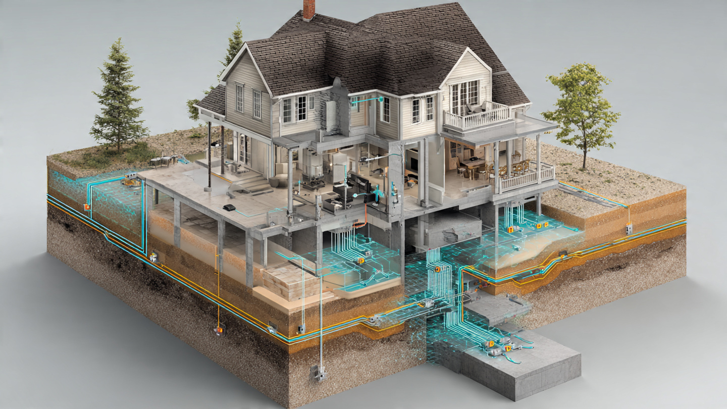
- Figure 1: System architecture showing a residential foundation plan view with tiltmeter node positions at 2-meter intervals along stem walls, soil moisture probe clusters at 4 locations around the perimeter, BLE mesh communication links, and central hub with WiFi uplink. Inset shows tiltmeter node cross-section with MEMS accelerometer, ADC, microcontroller, and battery.
- Figure 2: Graph structure visualization showing tiltmeter nodes (circles) and soil moisture nodes (diamonds) connected by edges representing spatial influence relationships. Edge thickness represents learned GAT attention weights, with thicker edges indicating stronger coupling. Color coding shows the four alert levels.
- Figure 3: Simulated time series showing soil moisture depletion at the 1.0 m depth probe (top panel) leading foundation tilt response (bottom panel) by approximately 4 weeks in a CH clay soil. The GAT prediction (dashed line) tracks the actual tilt trajectory, providing advance warning at the caution threshold 14 weeks before visible cracking would occur.
- Figure 4: GAT architecture diagram showing temporal convolution, two graph attention layers with multi-head attention, GRU temporal aggregation, and multi-task output heads for settlement rate, risk classification, and pattern identification.
Claims
- A system for predictive detection of residential foundation differential settlement, comprising: a plurality of MEMS-based tiltmeter nodes mounted on a building foundation at spatially distributed positions; one or more soil moisture sensors installed at one or more depths adjacent to the foundation perimeter; a communication network connecting said tiltmeter nodes and soil moisture sensors to a processing hub; and a graph neural network executing on said hub that models said tiltmeter nodes and soil moisture sensors as nodes in a spatially-connected graph with learned attention weights, wherein said graph neural network predicts differential settlement rates and structural risk levels from the spatiotemporal patterns of tilt and soil moisture measurements.
- The system of claim 1, wherein the graph neural network is a graph attention network (GAT) comprising at least two attention layers with multi-head attention, wherein attention weights between tiltmeter nodes and soil moisture nodes learn the site-specific lag time between soil volume change and structural tilt response without explicit lag specification.
- The system of claim 1, wherein each tiltmeter node comprises a dual-axis MEMS accelerometer operated in static tilt mode with a 24-bit analog-to-digital converter achieving effective tilt resolution of 0.001° or better through temporal averaging.
- The system of claim 1, wherein soil moisture sensors are installed at a minimum of two depths including an active zone depth (0.5–1.5 meters) where expansive clay volume change is greatest and a deep reference depth (2.0–3.0 meters) providing a stable moisture baseline.
- The system of claim 1, wherein the graph neural network produces multi-task outputs comprising: a per-node differential tilt rate prediction for a future time horizon; a per-node risk classification calibrated to structural engineering damage criteria for angular distortion; and a whole-foundation settlement pattern classification identifying canonical distress patterns.
- The system of claim 1, further comprising a commissioning module that operates during an initial deployment period to establish thermal calibration coefficients for each tiltmeter node, a baseline tilt profile of the foundation, and site-specific transfer learning adaptation of the graph neural network.
- The system of claim 1, further comprising a federated learning module that uploads model gradient updates from the processing hub to a cloud platform, where gradient updates from multiple installations are aggregated by soil classification and climate zone and redistributed to individual hubs to improve prediction accuracy without sharing raw sensor data.
- A method for predicting residential foundation differential settlement comprising: measuring foundation tilt at a plurality of spatially distributed points using MEMS-based inclinometers; measuring soil volumetric water content at one or more depths adjacent to the foundation; constructing a heterogeneous graph representation where tiltmeter measurements and soil moisture measurements are nodes connected by edges representing spatial influence relationships; processing said graph through a trained graph attention network to compute attention-weighted aggregation of neighbor features; and predicting differential settlement rate and structural risk level from the spatiotemporal patterns encoded in the graph attention network output.
- The method of claim 8, wherein the graph attention network is pre-trained on synthetic settlement scenarios generated by finite element simulation of soil-foundation interaction using an unsaturated soil mechanics constitutive model, and fine-tuned at each installation using self-supervised prediction of future tilt values from historical measurements.
- The method of claim 8, further comprising estimating a rainfall proxy from the rate of volumetric water content increase at a shallow soil depth without a dedicated rain gauge, and incorporating said rainfall proxy as a node feature in the graph attention network.
- The system of claim 1, wherein the alert thresholds are calibrated to the Skempton and MacDonald angular distortion framework, with early warning provided at projected angular distortions between 1/1000 and 1/500 where preventive interventions are effective, before the 1/300 threshold at which visible structural cracking typically manifests.
- The system of claim 1, wherein a smartphone application uses augmented reality measurement of foundation wall geometry to automatically generate the graph topology and optimize sensor placement positions based on structural stiffness analysis of the foundation plan.
Implementation Notes
A minimum viable deployment begins with a 12-node tiltmeter array and 9 soil moisture sensors (3 locations × 3 depths) installed on a slab-on-grade residential foundation in a region with expansive clay soils (Texas, Colorado Front Range, or California Central Valley are representative target markets). The BOM for this configuration totals $120–180 depending on sensor grade selection. The central hub (ESP32-S3 + microSD + enclosure) adds $25–40. The soil auger and mounting hardware add $30–50. Total retail target price: $250–400 per kit, compared to $2,000–$15,000 for a single professional surveying assessment and $2,200–$100,000 for foundation repair after damage has occurred.
The system prioritizes three deployment scenarios in order of impact: (1) homes within 10 meters of large deciduous trees on CH/CL soils, where tree root moisture extraction creates the most severe and predictable differential settlement patterns; (2) homes in areas experiencing drought-wet cycling (increasingly common under IPCC AR6 climate projections for intensified precipitation variability); and (3) homes adjacent to new construction or excavation where adjacent soil disturbance can trigger settlement in existing foundations. Insurance companies and real estate inspection firms represent natural distribution channels, as proactive monitoring data could support risk-based premium pricing and pre-sale structural assessment, respectively.
Prior Art References
- Skempton and MacDonald, Géotechnique 1956 — Allowable settlement of buildings (1/300 angular distortion threshold)
- Burland and Wroth, Géotechnique 1974 — Settlement of buildings and associated damage
- Topp et al., Soil Science Society of America Journal 1980 — Electromagnetic determination of soil water content
- Alonso et al., Computers and Geotechnics 2003 — Barcelona Basic Model for unsaturated soil mechanics
- Al-Rawas and Goosen, Engineering Geology 2006 — Expansive soils: recent advances in characterization and treatment
- McMahan et al., 2017 — Communication-Efficient Learning of Deep Networks from Decentralized Data (Federated Averaging)
- Bekaert et al., Remote Sensing of Environment 2020 — InSAR-based detection of subsidence and building damage
- Bado et al., Buildings 2020 — Review of MEMS-based structural health monitoring
- Soga et al., SPIE 2022 — Distributed fiber optic sensing for foundation settlement monitoring
- US10526763B2 — Structural foundation monitoring sensor system (threshold-based, no spatial graph modeling)
- US Census Bureau American Housing Survey — Housing stock statistics
- American Geosciences Institute — Expansive soils damage exceeds all other natural hazards combined
- Future Market Insights, 2025 — Foundation repair services market size $2.9B (2025), projected $4.4B (2035)
- Angi, 2026 — Foundation repair cost range $2,224–$8,134
- IPCC AR6 Working Group I — Climate change and intensified precipitation variability projections
- TensorFlow Lite for Microcontrollers — Edge ML inference runtime for resource-constrained devices