System and Method for Autonomous Detection, Classification, and Temporal Tracking of Construction Activity on Adjacent Properties Using Consumer Security Camera Networks with Edge-Deployed Phase Recognition and Automated Municipal Permit Cross-Referencing
Abstract
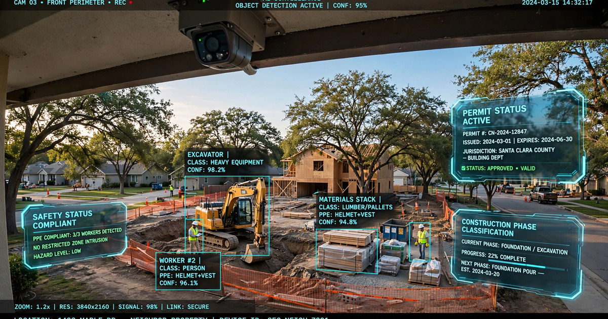
Disclosed is a system and method for autonomously detecting, classifying, and temporally tracking construction activity on adjacent or nearby properties using a network of existing consumer security cameras (e.g., Ring, Nest, Arlo, UniFi Protect). The system performs continuous temporal difference analysis on camera feeds to identify construction commencement events, classifies observed activity into discrete construction phases (demolition, site preparation/grading, foundation, framing, roofing, exterior finish, interior finish, landscaping) using an edge-deployed convolutional neural network trained on construction-specific visual features (heavy equipment silhouettes, material staging patterns, scaffolding geometries, worker density distributions), and cross-references detected activity against municipal building permit databases via standardized open data APIs (e.g., Building & Land Development Specification). The system generates alerts when construction activity is detected at addresses with no matching active permit, when observed work scope exceeds permitted scope (e.g., structural work on a cosmetic-only permit), or when project timelines exceed permitted durations. Multi-camera triangulation across participating neighbors enables 3D scene reconstruction for volumetric change estimation (excavation depth, structure height) and independent verification of permit-filed dimensions.
Field of the Invention
This invention relates to automated property monitoring and municipal code compliance, specifically to the repurposing of consumer-grade security camera networks for construction activity detection, phase classification, and automated cross-referencing with municipal building permit records to identify unpermitted or non-conforming construction work.
Background
Unpermitted construction is a pervasive problem in residential areas across the United States. The U.S. Census Bureau's Building Permits Survey tracks approximately 1.5 million residential building permits annually, but enforcement agencies estimate that unpermitted work accounts for 10-30% of all residential construction activity depending on jurisdiction. A 2019 Los Angeles Times investigation found that the City of LA issues approximately 120,000 building permits per year but receives over 35,000 complaints about unpermitted construction, with a median response time exceeding 30 days due to inspector staffing shortages.
Current detection methods for unpermitted construction are reactive and labor-intensive:
- Complaint-driven enforcement: Municipal code enforcement relies almost entirely on neighbor complaints filed via 311 systems, web portals, or phone calls. This creates an adversarial dynamic between neighbors, introduces reporting bias (wealthier neighborhoods file more complaints), and provides no temporal evidence of when work began.
- Periodic aerial surveys: Some jurisdictions (e.g., EagleView Reveal) contract aerial imagery for change detection, but flights occur at most annually, provide no information about active construction phases, and cannot distinguish permitted from unpermitted work without manual cross-referencing.
- Inspector drive-bys: Building inspectors occasionally identify unpermitted work during site visits for other permits, but this is incidental and unsystematic.
On the technology side, construction activity detection using computer vision has been demonstrated for on-site safety and progress monitoring. US12136052B2 (Procore Technologies) describes verification of construction progress via image comparison at a specific location, but operates from on-site cameras managed by the project owner and does not perform permit cross-referencing. US20210133646A1 describes a permit compliance system for environmental permits using mobile field officer input, not automated visual detection. EarthCam and Sitemetric deploy AI-powered cameras for construction site monitoring but focus on worker safety (PPE compliance, fall detection) rather than neighbor-facing construction detection or permit validation.
Consumer security cameras represent an enormous untapped sensor network. Statista estimates over 100 million outdoor security cameras deployed at U.S. residences as of 2025, with the majority capable of continuous recording and cloud connectivity. Ring alone has disclosed deployment at over 10 million homes. These cameras routinely capture views of adjacent properties, driveways, and street-facing construction activity as an incidental part of their coverage area.
Separately, municipal building permit data has become increasingly accessible through open data portals. The Building & Land Development Specification (BLDS) provides a standardized schema adopted by dozens of jurisdictions including Austin, TX; San Diego County, CA; Seattle, WA; Boston, MA; and others. The BLDS standard enables programmatic querying of permit status by address, permit type, issued date, expiration date, and scope of work.
The gap in the art is a system that: (a) repurposes existing consumer security cameras rather than requiring specialized equipment, (b) automatically detects construction commencement without requiring a human complaint, (c) classifies construction phases to determine work scope, (d) cross-references detected activity against municipal permit databases to identify compliance violations, and (e) provides timestamped photographic evidence of construction progression for enforcement and dispute resolution.
Detailed Description
1. Temporal Difference Analysis for Construction Commencement Detection
The system continuously computes temporal difference features on security camera feeds to detect construction commencement events. For each camera, the system maintains a rolling 30-day baseline of the visual scene by computing a per-pixel median image from frames sampled at 15-minute intervals during daylight hours (civil twilight to civil twilight, computed from GPS-derived latitude/longitude). This median baseline image inherently suppresses transient objects (vehicles, pedestrians, weather variations) while preserving stable scene elements (structures, landscaping, permanent fixtures).
Construction commencement is detected when the structural similarity index (SSIM) between the current scene and the baseline drops below a configurable threshold (default: 0.70) persistently for more than 48 consecutive hours. The 48-hour persistence requirement filters out transient events (moving vans, yard sales, tree removal) that temporarily alter the scene. Upon commencement detection, the system captures a high-resolution reference frame and initiates the construction phase classification pipeline.
To reduce false positives from seasonal changes (leaf growth/fall, snow cover), the system computes a seasonal adjustment factor by comparing the current baseline against baselines from the same calendar window in previous years (when available). Sudden structural changes exceeding the seasonal adjustment envelope trigger construction alerts even when absolute SSIM values remain above the threshold.
2. Construction Phase Classification
Once construction commencement is detected, the system deploys a multi-class convolutional neural network (CNN) classifier to categorize the observed activity into discrete construction phases. The classifier architecture uses a MobileNetV3-Large backbone (5.4M parameters, optimized for edge deployment) with a custom classification head producing probability vectors over the following phase categories:
- Phase 0 — Demolition: Characterized by debris piles, dumpster placement, heavy equipment with demolition attachments (hydraulic breakers, grapples), partial structure removal. Visual features: irregular rubble textures, exposed interior walls, dust clouds in temporal difference frames.
- Phase 1 — Site Preparation/Grading: Characterized by exposed earth, grading equipment (bulldozers, skid steers, compactors), survey stakes, silt fencing, portable toilets. Visual features: uniform bare soil texture, equipment tracks, grade changes detectable via shadow analysis.
- Phase 2 — Foundation: Characterized by excavation trenches, rebar placement, concrete trucks, form boards, waterproofing membranes. Visual features: geometric trench patterns, concrete pour events (temporal: grey surface appearance within 4-hour window).
- Phase 3 — Framing: Characterized by exposed dimensional lumber, roof trusses, sheathing panels, nail gun activity (detectable via audio channel if available). Visual features: linear wood-grain textures, regular stud spacing patterns, rapid vertical growth in structure height over 1-4 week window.
- Phase 4 — Roofing: Characterized by roof surface material staging, workers at height, scaffolding, underlayment rolls. Visual features: color change of uppermost structure surface, shingle/tile texture patterns.
- Phase 5 — Exterior Finish: Characterized by siding installation, window placement, stucco application, painting. Visual features: progressive color/texture uniformity of exterior surfaces.
- Phase 6 — Interior Finish: Characterized by reduced exterior activity, trade vehicle presence (HVAC, electrical, plumbing vans identified via logo detection or vehicle type classification), interior lighting patterns changing over time.
- Phase 7 — Landscaping/Final: Characterized by soil delivery, plant material, irrigation trenching, hardscape installation, final grading. Visual features: progressive vegetation appearance, geometric hardscape patterns.
The classifier processes frames at 1-hour intervals during detected construction periods, producing a smoothed phase probability distribution using a 24-hour sliding window. Phase transitions are logged with timestamp, confidence score, and representative frame. The model is trained on a dataset of 250,000+ annotated construction images sourced from public timelapse feeds (EarthCam archives, municipal construction webcams, YouTube construction timelapses) with manual phase annotations.
3. Municipal Permit Cross-Referencing
When construction commencement is detected, the system automatically queries the relevant municipal building permit database to determine whether active permits exist for the detected property. Address resolution proceeds as follows:
- The camera's GPS coordinates and known field of view (from camera calibration) are used to compute the approximate address of the construction activity using reverse geocoding (e.g., Google Maps Geocoding API, OpenStreetMap Nominatim).
- The resolved address is queried against the municipal permit database via BLDS-compliant API (where available) or web scraping of the jurisdiction's online permit portal (e.g., Accela Citizen Access, Tyler EnerGov, OpenGov).
- Permit records are filtered for active status (issued but not finalized) and temporal overlap (issue date before detected construction start, expiration date after current date).
The system performs three categories of compliance checks:
- No-Permit Alert: Construction activity detected at an address with no matching active building permit. This is the highest-priority alert, as it indicates potentially unpermitted work. The alert includes the detected construction phase, representative frames, and the date range of observed activity.
- Scope Mismatch Alert: Detected construction phase exceeds the scope of the active permit. For example, structural framing (Phase 3) detected at an address with only a "cosmetic renovation" or "re-roofing" permit. The system maps detected phases to permit type categories: demolition/grading/foundation/framing require structural permits; roofing requires roofing permits; exterior finish may require design review in historic districts; etc.
- Timeline Exceedance Alert: Construction activity persists beyond the permit's stated expiration or completion date. Many jurisdictions issue permits with 6-month or 12-month validity periods; expired-permit construction is a common violation.
4. Multi-Camera Triangulation and Volumetric Change Estimation
When multiple participating cameras from different vantage points observe the same construction site, the system performs multi-view stereo reconstruction to estimate 3D geometry changes. Using camera intrinsic parameters (focal length, distortion coefficients from manufacturer specifications or auto-calibration) and relative camera positions (derived from GPS coordinates and camera mounting height), the system computes dense depth maps via semi-global block matching (SGBM) or learned stereo (e.g., RAFT-Stereo).
By differencing 3D reconstructions over time, the system estimates:
- Excavation volume: Computed as the negative volumetric change below pre-construction grade level. Useful for verifying that excavation does not exceed permitted depth (e.g., basement depth specified in permit drawings).
- Structure height: Computed as the maximum positive volumetric change above pre-construction grade level. Enables automated verification that construction does not exceed permitted building height or zoning height limits. Height accuracy of ±0.3 meters is achievable with cameras spaced 20-50 meters apart at typical residential densities.
- Lot coverage: The 2D footprint of new construction projected onto the lot boundary (from parcel map data) enables automated computation of lot coverage ratio for zoning compliance (e.g., maximum 45% lot coverage in R-1 zoning).
- Setback verification: Distance from new construction to property lines, computed from the 3D reconstruction registered to the parcel map, enables automated verification of front, side, and rear setback requirements.
5. Privacy-Preserving Processing Architecture
All image processing is performed on-device (on the camera's edge processor or on a local hub such as a Ring Alarm Pro, Nest Hub, or UniFi Network Video Recorder) or on the homeowner's local network. Raw camera frames are never transmitted to a cloud service for construction analysis. The system transmits only: (a) construction commencement/phase change events with a single representative thumbnail per event (downsampled to 320×240, with human faces and license plates automatically blurred via on-device detection), (b) permit query results (address, permit type, status, dates), and (c) volumetric measurement summaries (excavation depth, building height, lot coverage ratio). This architecture ensures that the construction monitoring functionality does not create a new surveillance vector beyond the camera's existing recording scope.
Homeowners control which cameras participate in the construction monitoring network via explicit opt-in per camera. The system provides a transparency dashboard showing which neighbors have opted in, what construction events have been detected, and what permit queries have been executed. A "neighborly mode" option limits alerts to the camera owner only (no sharing with the neighborhood network) for homeowners who want monitoring without community participation.
6. Evidence Package Generation
When a compliance violation is detected (no permit, scope mismatch, or timeline exceedance), the system automatically assembles an evidence package suitable for submission to the municipal code enforcement agency. The package includes:
- Timestamped photographic evidence showing construction progression (one representative frame per day, faces/plates blurred)
- Construction phase classification timeline with confidence scores
- Permit database query results showing absence of permit or scope mismatch
- If multi-camera data is available: volumetric measurements (height, depth, footprint) with uncertainty bounds
- Pre-construction baseline photographs for comparison
- A machine-readable summary in JSON format compatible with common code enforcement case management systems (e.g., Accela, Tyler Munis, Cityworks)
The evidence package is presented to the homeowner for review before any submission. The homeowner may choose to: (a) submit the package to code enforcement via the municipal complaint portal (automated filing where API access is available), (b) share the evidence with their HOA or neighborhood association, (c) retain the evidence privately for potential future disputes, or (d) dismiss the alert as a false positive (feeding the classification model's false positive correction pipeline).
7. Figures Description
- Figure 1: System architecture diagram showing the flow from consumer security camera feeds through temporal difference analysis, construction phase classification, permit database cross-referencing, and alert generation, with privacy-preserving on-device processing boundaries indicated.
- Figure 2: Example temporal difference sequence showing construction commencement detection: 30-day baseline image, day-of-commencement frame, SSIM heatmap highlighting structural changes, and the 48-hour persistence filter timeline.
- Figure 3: Construction phase classification confusion matrix from validation dataset (250,000 images, 8 phases), showing per-phase precision and recall metrics.
- Figure 4: Multi-camera triangulation geometry for a three-camera neighborhood configuration, showing camera positions, overlapping fields of view, and computed 3D point cloud of a partially-constructed structure with height and setback measurements annotated.
- Figure 5: Evidence package example showing the timeline view of a detected unpermitted addition: daily progress photos, phase classification annotations, permit database query results (no matching permit found), and estimated building height exceeding zoning limit.
Claims
- A system for autonomous detection of construction activity on adjacent properties, comprising: one or more consumer security cameras deployed at a monitoring property; a processing module that performs temporal difference analysis on camera feeds against a rolling baseline to detect construction commencement events; and a construction phase classifier that categorizes detected activity into discrete construction phases using an edge-deployed convolutional neural network trained on construction-specific visual features.
- The system of claim 1, further comprising a permit cross-referencing module that: resolves the address of detected construction activity via reverse geocoding from the camera's known position and field of view; queries a municipal building permit database for active permits at the resolved address; and generates an alert when construction activity is detected at an address with no matching active building permit.
- The system of claim 2, wherein the permit cross-referencing module further generates a scope mismatch alert when the classified construction phase indicates work exceeding the scope of an active permit at the resolved address.
- The system of claim 2, wherein the permit cross-referencing module further generates a timeline exceedance alert when construction activity persists beyond the expiration date of the matching permit.
- The system of claim 1, wherein the temporal difference analysis computes a structural similarity index (SSIM) between current camera frames and a rolling per-pixel median baseline image, and detects construction commencement when the SSIM drops below a threshold persistently for a configurable duration.
- The system of claim 1, wherein the construction phase classifier distinguishes among at least demolition, site preparation, foundation, framing, roofing, exterior finish, interior finish, and landscaping phases based on visual features including equipment silhouettes, material textures, scaffolding geometries, and worker density distributions.
- The system of claim 1, further comprising a multi-camera triangulation module that performs multi-view stereo reconstruction using cameras from multiple participating properties to estimate three-dimensional geometry changes including excavation depth, structure height, lot coverage area, and setback distances from property lines.
- A method for automated construction permit compliance monitoring, comprising: continuously analyzing security camera feeds from a consumer camera network to detect construction commencement via temporal difference analysis; classifying detected construction activity into discrete phases using an edge-deployed neural network; querying municipal building permit databases for active permits at the construction address; comparing classified construction phases against permitted scope of work; and generating compliance alerts for unpermitted activity, scope mismatches, or timeline exceedances.
- The method of claim 8, further comprising assembling an evidence package including timestamped photographic progression, phase classification timeline, permit query results, and optionally volumetric measurements, formatted for submission to municipal code enforcement systems.
- The method of claim 8, wherein all image processing is performed on-device or on the homeowner's local network, with only construction event metadata, downsampled representative thumbnails with human faces and license plates blurred, and permit query summaries transmitted beyond the local network.
- The system of claim 1, wherein the temporal difference analysis incorporates a seasonal adjustment factor derived from historical baselines at corresponding calendar windows to suppress false positives from vegetation changes, snow cover, and other seasonal scene variations.
Prior Art References
- U.S. Census Bureau Building Permits Survey — National building permit statistics, approximately 1.5 million residential permits annually
- US12136052B2 (Procore Technologies) — Verification of progression of construction-related activity via image comparison (on-site, no permit cross-referencing)
- US20210133646A1 — Permit compliance system for environmental permits using mobile officer input (manual, not automated visual detection)
- US20160055594A1 — Method of using building permits to identify underinsured properties (insurance application, no visual detection)
- US20230419802A1 — Property monitoring alarm system with AI event classification (security-focused, not construction-specific)
- Building & Land Development Specification (BLDS) — Open data standard for building permit information adopted by dozens of U.S. jurisdictions
- EagleView Reveal — Aerial imagery change detection for property assessment (annual frequency, no real-time monitoring)
- Data.gov Building Permits datasets — 104+ municipal building permit datasets available through federal open data portal
- Tan & Le, 2019 — EfficientNet: Rethinking Model Scaling for Convolutional Neural Networks (foundation for edge-deployable CNN architectures)
- Howard et al., 2019 — MobileNetV3: Searching for MobileNetV3 (edge-optimized CNN backbone used in phase classifier)
- Lipson et al., 2021 — RAFT-Stereo: Multilevel Recurrent Field Transforms for Stereo Matching (multi-view 3D reconstruction)
- Statista Smart Home Market — U.S. smart home security camera deployment estimates (100M+ outdoor cameras)
- 35 U.S.C. § 102 — Conditions for patentability; novelty (prior art legal framework)